The Land & Streams
...and what Realtor & Google Maps don't show...
3011 is located on the west side of 184th Street...
-
five properties south of 32nd Avenue (and two north of 29A Ave.)
-
a 4.564 acre property
-
~260 feet wide and ~760 feet long.
Those are the numbers. But what these don't give you is the experience.

Lots of Sky
Bordered by trees on four sides, but with few in the centre, this property has only one main building on it. As a result, it gives the house a wide-open view of the western sky and sunsets from the second floor living room and deck.
What's more, because it's in the ALR (the Agricultural Land Reserve), no multi-unit residential developments can be built on or around it. And that means this view will likely be enjoyed for years to come...


Lots of Land
With 4.5+ acres & few buildings, it also means there is lots of land to enjoy!
So what would YOU to want to do with it?
-
Plan/build a new dream home
-
Create a small farm
-
Walk through nature
-
Enjoy the quiet, peaceful surroundings and wide-open space
-
Have a recreation area (e.g. near the pond at the back)
-
Or something else?


Two streams... and a Treed Pond
While Realtor/Google Maps don't show this, there are TWO streams which cross the 3011 property: Laura Brook and Vandrishe Creek.
Note the missing Creek name (in black),
and the incorrect location for Laura Brook, below

Here is where the two streams are actually located:
See the red lines in the white box (our property).

(All line locations are approximate)
Brief Descriptions
Laura Brook is a very small stream that flows underground from the neighbouring property, under their driveway, and to our pump shed where water is taken out for our house.
It then surfaces just north of our driveway, and flows in a small channel towards the neighbour's property to the north.
Here is a little taste of what it looks & sounds like, just behind our house...
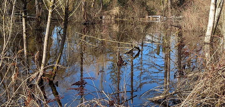
Vandrishe Creek is a larger, above-ground stream that flows from our neighbour's property to the south, and then crosses the west end of land.
Due to damming downstream (by humans + possibly beavers), Vandrishe Creek has also formed a large, 'treed' pond at the very back of our property.

And this is what it looks like
when you are there....


What might you do...
to enjoy them?